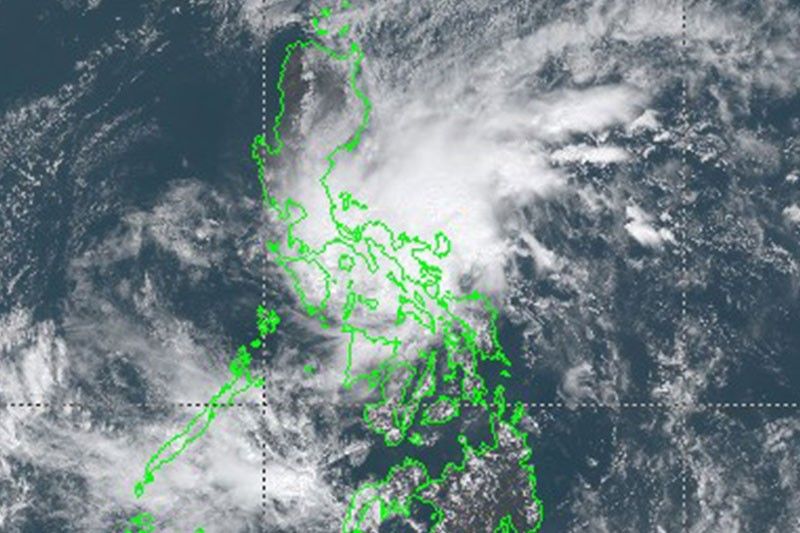
'Auring' makes landfall over Batag Island

MANILA, Philippines — Tropical Depression Auring on Monday made landfall over Batag Island in Laoang, Northern Samar, state weather bureau PAGASA says.
The tropical cyclone made landfall at 9 a.m. is heading towards the Albay-Sorsogon area.
At 10 a.m., Auring was seen 30 km northeast of Catarman, Northern Samar with winds of 45 kph and gusts of 55 kph. It is moving north northwestward at 15 kph.
Tropical cyclone wind signal no. 1 ( winds of 30 to 60 kph in the next 36 hours) is hoisted over the following areas:
Luzon
- Sorsogon
- Masbate including Ticao and Burias Islands
- Albay
- Catanduanes
- the eastern portion of Camarines Sur (Caramoan, Presentacion, Sagnay, Buhi, Iriga City, Nabua, Bato, Balatan)
Visayas
- Northern Samar
- Eastern Samar
- Samar
- Biliran
PAGASA said Auring will weaken into a remnant low within 24 hours or sooner due to significant terrain interaction.
Areas under signal no. 1 will experience the combined effects of the northeast monsoon or amihan and Auring, which will bring strong breeze conditions with occasionally higher gusts.
Batanes, Babuyan Islands, Aurora, Quezon, Marinduque, Romblon, Oriental Mindoro, Cuyo Islands, Cagayancillo Islands, Western Visayas, and the rest of Eastern Visayas and Bicol Region will also experience the same effects.
"Under these conditions, isolated to scattered flooding (including flash floods) and rain-induced landslides are still likely during heavy or prolonged rainfall especially in areas that are highly or very highly susceptible to these hazards as identified in hazard maps and in localities that received significant rainfall over the past couple of days," the weather bureau said.
Hazards affecting coastal waters
Rough seas
- the seaboards of areas under TCWS #1
- the eastern seaboard of Central Luzon
- the eastern seaboard of Southern Luzon not under any TCWS (2.5 to 3.5 m)
- the southern seaboard of Luzon and the remaining seaboards of Eastern Visayas (2.5 to 3.0 m)
Moderate to rough seas
- the remaining seaboards of Luzon and Visayas
- the northern, eastern, and western seaboards of Mindanao not under any TCWS
Follow this thread for updates on Auring, the first tropical cyclone to enter the Philippines this year. (Main photo: JMA)
The number of missing residents due to tropical cyclone Auring grows to four, according to the NDRRMC.
Search and rescue operations for the missing persons from a capsized boat in Surigao del Norte are ongoing.
The NDRRMC also records 1 death due to drowning and two injured — one due to galvanized iron sheets and the other struck by lightning.
"Auring" weakens into a low pressure area as it moves towards the eastern coast of Albay.
State weather bureau PAGASA says the weather disturbance may traverse Bicol Region, southern Quezon, Marinduque and northern Mindoro in the next 24 hours.
At 1 p.m., it was located over the coastal waters of Rapu-Rapu, Albay.
Tropical Depression Auring has made landfall over Batag Island in Laoang, Northern Samar at 9 a.m., PAGASA says.
At 9:00 AM today, the center of Tropical Depression #AuringPH made landfall over Batag Island, Laoang, Northern Samar.
Posted by Dost_pagasa on Sunday, 21 February 2021
Tropical Depression Auring is expected to make landfall over the Dinagat Islands-Eastern Samar-Leyte area in the next 6 to 12 hours.
State weather bureau PAGASA says the weather disturbance is likely to further weaken before it makes landfall due to persistent high vertical wind shear brought about by the northeast monsoon or amihan.
At 4 a.m., Auring was located 195 km east of Maasin City, Southern Leyte with winds of 45 kph and gusts of up to 55 kph. It is moving west northwestward at 15 kph.
PAGASA says Tropical Storm Auring has slightly weakened while moving northwestward.
As of 4 p.m. Saturday, the eye of Auring was spotted 440 kilometers east southeast of Hinatuan, Surigao del Sur.
Moving northwestward at 15 kilometers per hour, it has maximum sustained winds of 65 kph near the center and gustiness of up to 80 kph.
- Latest
- Trending


