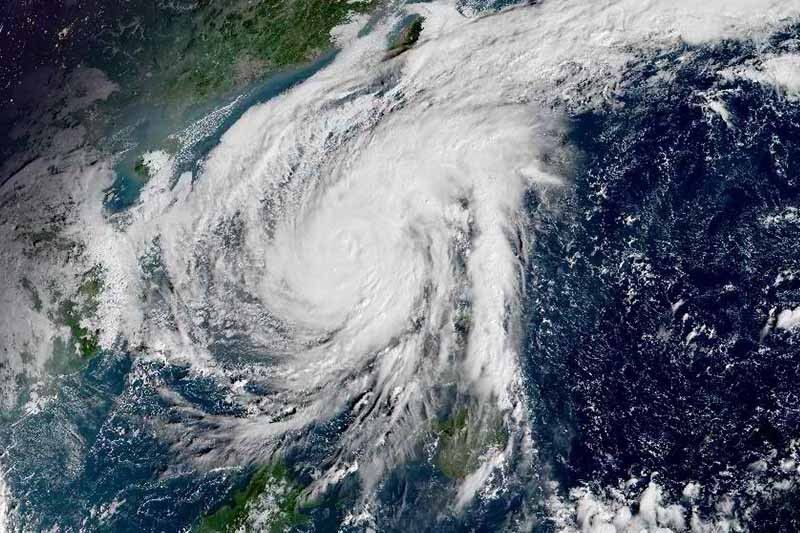
Typhoon Ulysses weakens with exit seen Friday

MANILA, Philippines — After leaving devastation on its path, Typhoon Ulysses (international name: Vamco) weakened and its strength expected to continue moderating while on the way out of the Philippines by Friday.
In a bulletin released past 8 a.m., the weather bureau said Ulysses—the 21st cyclone this year—was last seen in the vicinity of Cabangan, Zambales.
The typhoon now packs peak winds of 130 kilometers per hour near the center from the previous 155 kph. Gustiness also moderated to peak at 215 kph from the previous 255 kph. Forecasters said the cyclone is likely to weaken further as it crosses Sierra Madre and Zambales mountain ranges in Central Luzon.
That said, since strength is measured by how strong winds are, rains are not exactly expected to temper as well. Heavy to intense, with at times torrential rains, are still seen over Metro Manila, Calabarzon and Central Luzon throughout the day.
The typhoon surprised residents in the capital region overnight after howling winds and strong rains disrupted what could have been a peaceful sleep. In Marikina City, “Ulysses” prompted evacuation when water level in the river rose and brought back grim memories of Ondoy that caused severe flooding in September 2009.
Weathermen however insisted they did not fail in warning about the storm’s strength, especially after Super Typhoon Rolly (international name: Goni) turned out to be weaker than expected when it reached National Capital Region.
Meanwhile, moderate to heavy with at times intense rains will be experienced in Cordillera Administrative Region, mainland Cagayan Valley, Babuyan Islands, Pangasinan, Marinduque, and the northern portion of Mindoro provinces including Lubang Island.
Between Thursday afternoon and evening, moderate to heavy rains will prevail over CAR, eastern portions of Cagayan and Isabela, Zambales, Bataan, Aurora, Metro Manila, Cavite, western portion of Batangas, and the northern portion of Occidental Mindoro.
Tropical Cyclone Wind Signal No. 3 (destructive typhoon-force winds )
- Northern portion of Cavite (Naic, Tanza, Ternate, Maragondon, Rosario, Noveleta, Cavite City, Kawit, Bacoor, Imus, General Trias, Trece Martires City, Dasmariñas)
- Metro Manila
- Western portion of Bulacan (San Miguel, San Ildefonso, San Rafael, Angat, Santa Maria, Marilao, Meycauayan City, Obando, Bulacan, Bocaue, Pandi, Bustos, Baliuag, Plaridel, Balagtas, Guiguinto, Malolos City, Paombong, Hagonoy, Calumpit, Pulilan)
- Western portion of Nueva Ecija (Gapan City, Peñaranda, Santa Rosa, Cabanatuan City, General Mamerto Natividad, Llanera, San Jose City, Lupao, Cabiao, San Isidro, San Leonardo, Jaen, San Antonio, Zaragoza, Aliaga, Talavera, Licab, Quezon, Santo Domingo, Guimba, Muñoz City, Talugtug, Cuyapo, Nampicuan)
- Pampanga
- Tarlac
- Bataan
- Zambales
- Pangasinan
Tropical Cyclone Wind Signal No. 2 (damaging gale- to storm-force winds)
- Central and southern portions of Isabela (Mallig, Quirino, Ilagan, Roxas, Burgos, Gamu, Palanan, San Mariano, Dinapigue, San Guillermo, Benito Soliven, Naguilian, Reina Mercedes, Luna, San Manuel, Aurora, Cabatuan, Cauayan City, San Mateo, Alicia, Angadanan, Echague, Jones, San Agustin, San Isidro, Ramon, Santiago City, Cordon),
- Quirino
- Nueva Vizcaya
- Mountain Province
- Ifugao
- Benguet,
- Southern portion of Ilocos Sur (Cervantes, Quirino, San Emilio, Lidlidda, Santiago, Banayoyo, Candon City, Galimuyod, Gregorio Del Pilar, Salcedo, Santa Lucia, Santa Cruz, Sigay, Suyo, Tagudin, Alilem, Sugpon)
- La Union
- Aurora
- Rest of Nueva Ecija,
- Rest of Bulacan
- Northern and central portion of Quezon (San Antonio, Tiaong, Dolores, Candelaria, Sariaya, Lucban, Tayabas City, Lucena City, Pagbilao, Perez, Alabat, Atimonan, Padre Burgos, Agdangan, Plaridel, Mauban, Sampaloc, Real, General Nakar, Infanta) including Polillo Islands
- Rizal
- Laguna
- Rest of Cavite
- Batangas
- Northern portion of Oriental Mindoro (Puerto Galera, San Teodoro, Baco, Calapan City)
- Northern portion of Occidental Mindoro (Paluan, Abra de Ilog) including Lubang Island
Tropical Cyclone Wind Signal No. 1 (strong breeze to near gale conditions)
- Rest of Isabela
- Kalinga
- Abra
- Rest of Ilocos Sur
- Rest of Occidental Mindoro
- Rest of Oriental Mindoro
- Marinduque,
- Northern portion of Romblon (Corcuera, Banton, Concepcion),
- Rest of Quezon
- Camarines Norte
- Western portion of Camarines Sur (Siruma, Tinambac, Calabanga, Bombon, Magarao, Canaman, Camaligan, Gainza, Pamplona, Pasacao, Libmanan, Cabusao, Sipocot, Lupi, Ragay, Del Gallego)
Storm surge and other hazards affecting coastal waters
PAGASA, the weather agency, warned there is “high risk” of storm surge of up to 3 meters over coastal areas of Aurora, Quezon, as well as Cavite, Metro Manila, Bulacan, Pampanga, Bataan, and Zambales. The same can be expected in coastal communities in Isabela, La Union, Pangasinan, Batangas, Marinduque, and the northern portion of Mindoro Provinces including Lubang Island.
“These storm surges, which may be accompanied by swells and/or breaking waves near the coast, can cause life-threatening and damaging coastal inundation. Moreover, there is also a moderate risk of seiche or storm surge over the coastal areas surrounding Laguna de Bay,” PAGASA said.
Ulysses and the surge of northeast monsoon will also bring rough to very high seas (2.5 to 10 meters) over the seaboards of areas under TCWS and the northern seaboard of Northern Samar, ough to high seas (3.0 to 6.0 m) over the remaining seaboards of Northern Luzon, and rough to very rough seas (2.5 to 4.5 m) over the western seaboard of Palawan including Calamian and Kalayaan Islands and the seaboards of Romblon and Bicol Region not under TCWS.
Sea travel is risky for all types of vessels over these waters.
Forecast positions
- Friday morning: 460 km west of Iba, Zambales
- Saturday morning: 900 km west of Central Luzon
— Gaea Katreena Cabico
- Latest
- Trending


