Storm Ulysses to hit Bicol, Quezon

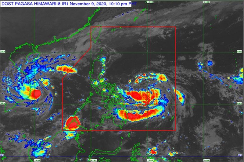
MANILA, Philippines — Tropical Storm Ulysses is expected to strengthen into a typhoon before its forecast landfall over the Bicol region-Quezon area tomorrow or Thursday, the state weather bureau has warned.
Ulysses was expected to further intensify into severe tropical storm category within 24 hours and may reach typhoon category, the Philippine Atmospheric, Geophysical and Astronomical Services Administration (PAGASA) said yesterday.
“A landfall over the Bicol region-Quezon area on Thursday is likely at this time,” it said.
As of 4 p.m. yesterday, the center of Ulysses was located at 575 kilometers east of Borongan City, Eastern Samar, packing winds of 65 kilometers per hour near the center and gustiness of up to 80 kph.
Ulysses, the 21st cyclone to enter the country this year, slowed down as it moved northwest from 40 kph earlier in the day to 15 kph yesterday afternoon.
PAGASA said the trough or extension of Ulysses started to bring light to moderate to at times heavy rains over Eastern Visayas, Bicol region and Quezon.
PAGASA senior weather forecaster Chris Perez said starting today, rains with gusty winds are likely to affect the Bicol region as Ulysses moves closer to landmass.
The Bicol region was the hardest hit area by Super Typhoon Rolly (international name Goni), which lashed the country on Nov. 1, killing at least 22 people.
The cyclone is expected to cross Southern Luzon in the next three days, Perez said.
“We advise the public not just in Bicol and Quezon but also in all provinces in Southern Luzon, Eastern Visayas, Central Luzon and even in Metro Manila to prepare for possible inclement weather due to Ulysses,” Perez said.
PAGASA was expected to raise tropical cyclone wind signal No. 1 over some parts of the Bicol region or Eastern Visayas last night or early this morning in anticipation of gusty winds from Ulysses.
The tail-end of a cold front, meanwhile, was bringing moderate to heavy rains over Cagayan, including the Babuyan Islands, Apayao and Ilocos Norte.
PAGASA also warned against rough to very rough seas with wave heights expected to reach as high as 4.5 meters over the entire seaboards of Northern Luzon, eastern seaboard of Central Luzon, and eastern and western seaboards of Southern Luzon.
Ulysses is expected to exit the Philippine area of responsibility on Saturday.
Meanwhile, Tropical Depression Tonyo (Etau) intensified into a storm as it exited the Philippine area of responsibility early yesterday morning.
Tonyo continued to bring moderate to heavy rains over the Kalayaan Islands as well as moderate to rough seas over the western seaboards of Bataan, Batangas, Occidental Mindoro including Lubang Island, and Palawan including Calamian Islands as it moved west toward Vietnam.
As of 4 a.m. yesterday, the center of the storm was spotted 710 kms. west of Calapan City, Oriental Mindoro, packing winds of 65 kph near the center and gustiness of up to 80 kph.
It was forecast to move west at 30 kph.
The storm was forecast to make landfall over the southern portion of Vietnam this morning or afternoon.
The National Disaster Risk Reduction and Management Council (NDRRMC) advised residents of Eastern Visayas and the Bicol region to prepare early for Ulysses.
“We are already advising Regional Disaster Risk Reduction Management Councils and local government units to start preparations already,” NDRRMC spokesman Mark Timbal said.
He added that those who are still in evacuation centers because of Typhoon Rolly are being advised to extend their stay in temporary shelters as Ulysses passes through the country.
Timbal gave assurance that the NDRRMC, in coordination with other government agencies, is continuously sending supplies and food packs to affected areas like Bicol and Catanduanes.
He said the delivery of food and other needs might be suspended for a while as the storm passes but delivery and distribution will resume immediately afterwards. – Michael Punongbayan
- Latest
- Trending


