Tropical storm 'Siony' enters Philippines with 'Rolly' still in the country
MANILA, Philippines — Tropical storm Atsani (international name) on Sunday entered the Philippine Area of Responsibility to become "Siony," with a present typhoon still threatening various parts of the country, PAGASA said.
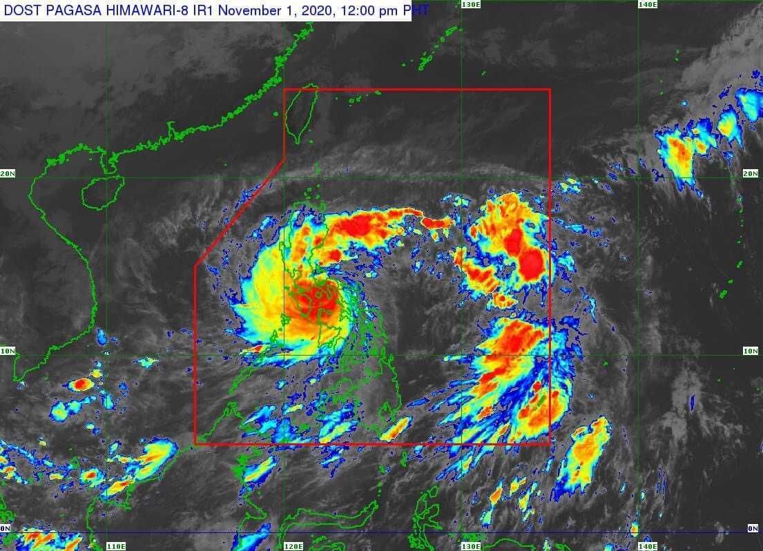
Siony, the 19th storm to hit the Philippines this year, entered PAR at 8 a.m. and was last seen at 1,365 km east of Central Luzon.
It has since intensified and now has maximum sustained winds of 75 kph with gustiness of up to 90 kph.
PAGASA said Siony continues to move west northwestward at a speed of 30 kph, but is “less likely to affect any portion of the country over the next two to three days.”
It is seen to move towards areas in Cagayan and Batanes until Friday.
Siony's entering the country comes at the heels of Typhoon Rolly ravaging Bicol region, with disaster officials reporting that nearly 347,000 have been evacuated so far.
Rolly has weakened into typhoon status as it moves toward Camarines Sur, but severe flooding is still seen in Quezon Province.
While no tropical cyclone wind signals have been raised so far due to Siony, the weather bureau is advising the public to continue monitoring its bulletins and for local officials to take appropriate actions.
PAGASA in October declared the onset of the La Niña in the country where above normal rainfall conditions may be experienced and five to eight tropical cyclones may enter until March 2021.
Forecast Positions
- Monday morning: 895 km East of Aparri, Cagayan
- Tuesday morning: 785 km East Southeast of Basco, Batanes
- Wednesday morning: 780 km East of Calayan, Cagayan
- Thursday morning: 530 km East of Aparri, Cagayan
- Friday morning: 40 km Southwest of Calayan, Cagayan
.jpg)


Follow this thread for updates on tropical storm Siony (international name: Atsani).
Severe Tropical Storm Siony is forecast to make landfall or a close approach over Batanes on Friday morning, PAGASA says.
Siony, which is expected to exit the Philippine Area of Responsibility by Friday evening, was 60 km east northeast of Basco, Batanes as of early Friday morning and moving Westward at 20 km/h.
The severe tropical storm has maximum sustained winds of 95 km/h near the center and gustiness of up to 115 km/h.
Tropical Cyclone Wind Signal No. 2 (winds of greater than 61 km/h and up to 120 km/h may be expected in at least 24 hours) is up over Batanes and the Babuyan Islands.
The following areas are under TCWS No.1 (winds of 30-60 km/h may be expected in at least 36 hours):
- Northern portion of mainland Cagayan (Santa Ana, Gonzaga, Lal-Lo, Allacapan, Santa Teresita, Buguey, Camalaniugan, Aparri, Ballesteros, Abulug, Pamplona, Sanchez-Mira, Claveria, Santa Praxedes)
- Northern portion of Apayao (Santa Marcela, Luna, Calanasan)
- Northern portion of Ilocos Norte (Adams, Pagudpud, Bangui, Dumalneg, Burgos, Vintar, Pasuquin, Bacarra)
Severe Tropical Storm Siony continues to move west-northwestward. It is expected to pass near Batanes within the next six hours.
At 10:00 p.m. Thursday, the eye of "Siony" was spotted 170 kilometers east of Basco, Batanes.
It is bearing peak winds of 100 kilometers per hour near the center and gusts of up to 125 kph. It is moving west northwestward at 20 kph.
PAGASA says Severe Tropical Storm Siony has maintained its strength while moving closer to Batanes.
At 7 p.m. Thursday, "Siony" was located 255 kilometers east of Basco, Batanes.
It is bearing peak winds of 100 kilometers per hour near the center and gusts of up to 125 kph. It is moving west northwestward at 20 kph.
Severe Tropical Storm Siony slightly intensifies as it barrels toward Luzon Strait.
Signal No. 2 is still raised over Batanes and Babuyan Island.
In its 5 p.m. advisory, PAGASA says the center of "Siony" was spotted 340 kilometers east of Basco, Batanes.
Signal No. 2 is still hoisted over Batanes and Babuyan Islands as Severe Tropical Storm Siony continues to move westward towards Luzon Strait.
As of 1:00 p.m. Thursday, the eye of "Siony" was spotted 360 kilometers east of Basco, Batanes.
Moving westward at 25 kilometers per hour, "Siony" has maximum sustained wind of 95 kph near the center and gustiness of up to 115 kph.


- Latest
- Trending