Severe flooding seen in Quezon despite 'Rolly' weakening into typhoon
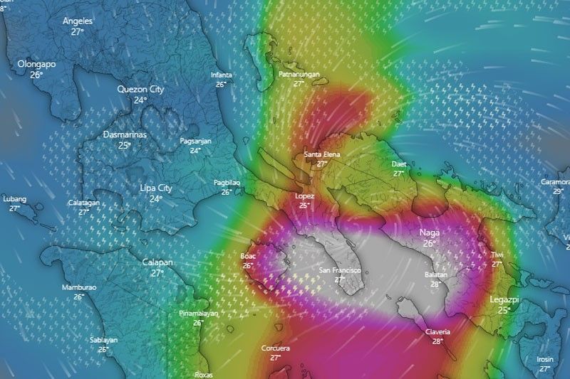
MANILA, Philippines — PAGASA has warned that serious flooding in flood-prone areas in Quezon Province should be expected despite the weakening of Typhoon Rolly after two landfalls so far.
As of 12 p.m. of Sunday, the following areas in Quezon are under red warning:
- Gumaca
- Pitogo
- San Narciso
- San Francisco
- San Andres
- Mulanay
- Buenavista
- Catanauan
- Tagkawayan
- Guinayangan
- Calauag
- Lopez
- Padre Burgos
- Agdangan
- Plaridel
- Unisan
- General Luna
- Macalelon
- Perez
- Quezon
- Alaban
- Atimonan
This means that community response or taking necessary precautionary measures is needed, with the threat of severe flooding looming.
Yellow warning, meanwhile, which means flooding in flood-prone areas, is up over these remaining places in Quezon, as well as in Batangas province:
Batangas
- Padre Garcia
- Ibaan
- Batangas City
- Rosario
- Taysan
- Lobo
- San Juan
Quezon:
- General Nakar
- Infanta
- Real
- Panukulan
- Burdeos
- Polilio
- Patnanungan
- Jomalig
- Mauban
- Sampaloc
- Lucban
- Tayabas
- Pagbilao
- Lucena
- Sariaya
- Candelaria
- Dolores
- Tiaong
- San Antonio
Metro Manila, Tarlac, Nueva Ecija, Zambales, Bataan, Pampanga, Bulacan, Cavite, Laguna, Rizal and the rest of Batangas, meanwhile, will see light to moderate with occasional heavy rains through the day.
Rolly first made landfall in Bato, Catanduanes early Sunday morning and next in Tiwi in Albay as a super typhoon, with storm signals reaching up to No. 5, PAGASA's highest.
It has since weakened into a typhoon and was last spotted off the coast of Pasacao in Camarines Sur.
Currently, it packs the strength of 215 kph maximum sustained winds and gustiness of up to 295 kph.
Rolly continues to move westward at 25 kph and is seen to exit the Philippine Area of Responsibility by Monday morning. — Christian Deiparine


- Latest
- Trending