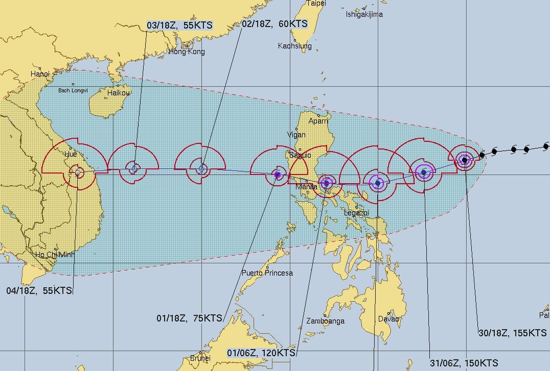
US agency upgrades Rolly to super typhoon while over Philippine Sea

MANILA, Philippines (Updated 10:17 a.m.) — The United States Navy's weather bureau reported an intensified Typhoon Rolly (international name Goni) overnight, reaching super typhoon category with 286 kilometers per hour maximum winds as it barrels across the Philippine Sea toward land on Saturday morning.
In its 9:30 a.m. advisory, the Joint Typhoon Weather Center recorded gusts of up to 351 kph while off the coast of Bicol, moving west-southwestward at 18 kph.
US weather agencies categorize typhoons with maximum surface sustained winds of 130 knots or 240 kph and higher as super typhoons.
The JTWC forecasts that Rolly will be slightly less intense with winds of 150 knots or 277 kph and gusts of 180 knots or 333 kph later during the day. It will further weaken to 140 knots or 259 kph on Saturday evening.
By November 1, Sunday, Rolly is expected to return to typhoon status with 120 knots or 222 kph winds as it hovers over land.
There are slight differences in the JTWC's measurement of cyclones in the western Pacific as it observes United States' standard of one-minute maximum sustained winds instead of the World Meteorological Organization's 10-minute measuring guideline. The WMO does not designate the JTWC among its cyclone warning centers as it aims to serve mainly US government agencies including its military.
The Philippines' state weather agency, PAGASA, observes the 10-minute interval in measuring cyclones and forecasted that Rolly is near super typhoon strength as of 8 a.m. on Saturday.
The typhoon was packing 215 kph winds near its center ang gusts of up to 265 kph, moving westward at 20 kph, according to PAGASA.
READ the report on PAGASA's 8 a.m. advisory: ‘Rolly’ may become a super typhoon in 12 hours
- Latest
- Trending


