Parts of Ilocos region under Signal No. 1 due to 'Ferdie'

MANILA, Philippines — Heavy rains will affect parts of Luzon Monday due to the combined effects of Tropical Depression Ferdie and the enhanced southwest monsoon, PAGASA said.
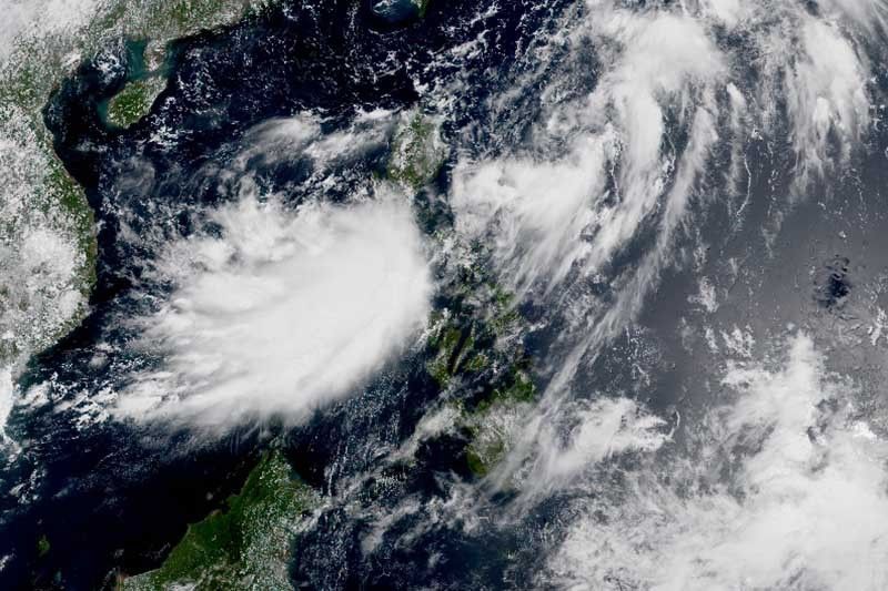
“Ferdie” was last seen 210 kilometers west northwest of Sinait, Ilocos Sur or 210 km west of Laoag City, Ilocos Norte packing peak winds of 55 km per hour near the center and gusts of up to 70 kph.
The tropical depression is moving north at 20 kph. It is expected to leave the Philippine Area of Responsibility this morning.
Weather forecasters raised Tropical Cyclone Wind Signal No. 1 over the following areas:
- Western portion of Ilocos Norte (Badoc, Pinili, Currimao, Batac City, Paoay, San Nicolas, Laoag City, Pasuquin, Bacarra, Burgos)
- Western portion of Ilocos Sur (Magsingal, Santo Domingo, San Ildefonso, San Vicente, San Juan, Cabugao, Sinait, Santa Catalina)
The combined effects of “Ferdie” and the enhanced southwest monsoon will bring strong breeze-force to near gale-force winds over Ilocos region, Cordillera Administrative Region, Cagayan Valley, Central Luzon, Metro Manila, Calabarzon, Mimaroa, especially in areas under TCWS No. 1.
Gusty conditions are more likely to prevail over coastal and mountainous regions of these areas.
The two weather systems will also dump monsoon rains over Ilocos region, Abra, Benguet, Zambales and Bataan. Meanwhile, occasional rains will affect Batanes, Cagayan, Metro Manila, Calabarzon, Mimaropa and the rest of Cordillera Administrative Region and Central Luzon.
In a Heavy Rainfall Warning issued at 8 a.m., PAGASA said yellow warning is raised over Floridablanca and Lubao in Pampanga, Bataan and Zambales. Flooding may occur in flood-prone areas.
Light to moderate with occasional heavy rains will affect Tarlac, Nueva Ecija, Cavite and Batangas within the next three hours. Meanwhile, light to moderate with occasional heavy rains may persist within three hours in Metro Manila, Bulacan and the rest of Pampanga.
PAGASA warned that sea travel is risk over the seaboards of areas under TCWS #1 due to rough to very rough seas. It is also risky to venture out over the seaboards of Zambales, Bataan, western coast of Batangas, western coast of Occidental Mindoro including Lubang Islands and Calamian Islands, Batanes, Cagayan including Babuyan Islands and Isabela.
Meanwhile, those with small seacrafts are advised to take precautionary measures while venturing out over the seaboards of Visayas and Luzon due to moderate to rough seas.
Forecast positions
- Tuesday morning: 390 km west northwest of Basco, Batanes (outside PAR)
- Wednesday morning: 930 km north northwest of Extreme Northern Luzon (outside PAR)
— Gaea Katreena Cabico
Follow this thread for updates on Tropical Depression Ferdie.
Photo: RAMMB
Tropical Depression Ferdie has exited the Philippine area of responsibility, state weather bureau PAGASA says.
The weather disturbance is forecast to move generally northward over the West Philippine Sea and make landfall over Fujian province in China Tuesday morning.
At 10 a.m., it was located 265 kilometers west northwest of Laoag City, Ilocos Norte or 315 kilometers west of Calayan, Cagayan. It packs maximum sustained winds of 55kph and gusts of up to 70 kph.
The western portions of Ilocos Norte and Ilocos Sur are under Tropical Cyclone Wind Signal No. 1 as Tropical Depression Ferdie approaches the northwestern border of the Philippine area of responsibility.
The weather disturbance is forecast to reach tropical storm category by Monday night or Tuesday morning and weaken into a low pressure area Tuesday evening after landfall.
At 4 a.m., Ferdie was located 210 kilometers west northwest of Sinait, Ilocos Sur or 210 kilometers west of Laoag City, Ilocos Norte.
- Latest
- Trending


