Why there are dazzling lightning displays during eruptions and other volcano facts

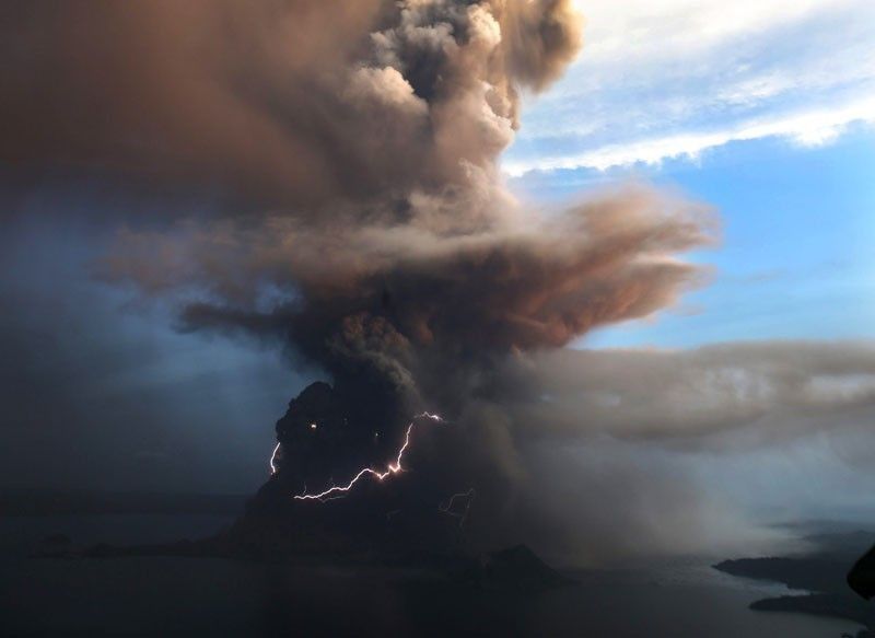
MANILA, Philippines — The eruption of Taal Volcano near the Philippine capital has delivered a dazzling but highly dangerous spectacle since it began spewing superheated steam on Sunday.
Taal Volcano's bursts of lightning and monster clouds of ash have drawn crowds of gaping observers, but also prompted thousands to flee from its fury.
Here are five facts about the mix of beauty and terror that volcanoes produce:
Lightning
Large eruptions sometimes put on a stunning display of lightning strikes that illuminate the massive cloud of ash surrounding them.
This has happened repeatedly above the Taal Volcano and been captured in videos shared widely across social media.
It is a relatively unusual and difficult to study the phenomenon, so there is some scientific dispute about how and why it happens.
One theory posits that particles bashed together in the chaos of the eruption create static electricity which eventually results in lightning.
However, Indriati Retno Palupi, a volcanologist and geologist, told AFP lightning can be created when ashes containing chemical elements react with gasses in the surrounding air.
Tsunamis
A violent eruption could trigger a deadly rush of waves by displacing water with rising magma or an avalanche of debris, according to the Philippine Institute of Volcanology and Seismology.
In fact, the 1980 eruption of Mount St. Helens in the US state of Washington produced a 780-foot (235-metre) tsunami, according to the International Tsunami Information Center.
The wall of water was unleashed by the partial collapse of the volcano's flank and a fast-moving avalanche of debris.
Million volcanoes?
Around 1,500 potentially active volcanoes are present around the world, many of which are found on the Pacific "Ring of Fire," where tectonic plates collide deep below the earth's surface.
However, around 75% of volcanic activity on Earth occurs underwater. Undersea eruptions, the National Oceanic and Atmospheric Administration say, are "a constant process that shapes the features of the ocean."
Oregon State University geologists estimate there could be as many as a million called "submarine volcanoes."
Global cooling
The 1991 eruption of Mount Pinatubo, about 100 kilometers (60 miles) northwest of Manila, was the Philippines' most powerful in recent years and killed more than 800 people.
However, the eruption had a worldwide impact.
Nearly 20 million tons of sulfur dioxide were shot skyward by Pinatubo, which then drifted globally.
"This gas cloud... caused global temperatures to drop temporarily (1991 through 1993) by about 1°F (0.5°C)," according to a US Geological Survey account of the eruption.
On top of the cooler temperatures, the gases and ash sent high in the sky by Pinatubo also caused "brilliant sunsets and sunrises," USGS said.
Indonesia's killer volcanoes
Indonesia is the world's most volcanic area.
The Southeast Asian archipelago of more than 17,000 islands and islets — and nearly 130 active volcanoes — is situated on the Pacific "Ring of Fire."
In 1815, Mount Tambora on the island of Sumbawa exploded in one of the most violent eruptions in recorded history. An estimated 12,000 people died, while a resulting famine killed another 80,000.
The island of Krakatoa was practically wiped off the map in 1883 by a volcanic explosion so powerful that it was heard some 4,500 kilometers (2,800 miles) away.
Around 36,000 people were killed in the eruption and the resulting tsunami. A new volcano emerged in 1928 on the same site.
Get updates as Phivolcs issues warnings over activity in Taal Volcano. (Main photo by Philstar.com/Rosette Adel)
The Philippine Institute of Volcanology and Seismology issues a notice reporting an increased and continuous degassing activity from Taal Volcano.
In its 6 p.m. advisory, Phivolcs says the sulfur dioxide emission from the main crater reached 9762 tonnes per day. This was the higher recorded this year.
Phivolcs adds that there was no smog or vog observed. — Rosette Adel
The Philippine Institute of Volcanology and Seismology says Taal Volcano is still under Alert Level 1.
In an update on Wednesday, its says that the daily sulfur dioxide emissions (SO2) reached 2887 tonnes / day (06 October 2023).
Phivolcs also observes upwelling of hot volcanic fluids in the Main Crater Lake. — Rosette Adel
The Philippine Institute of Volcanology and Seismology reports that Taal Volcano's daily sulfur dioxide emissions (SO2) reached 2887 tonnes.
It observes upwelling of hot volcanic fluids in the Main Crater Lake as well as volcanic smog or vog.
The volcano's emissions are also 2400 meters tall. — Rosette Adel
The Philippine Institute of Volcanology and Seismology releases time-lapse snapshots of degassing activity from the Taal Main Crater and volcanic smog or vog formation on Sunday.
These were taken from 5:45 a.m. to 11:42 a.m. by the Mt. Macolot, Cuenca, Batangas station (VTCU) IP Camera.
LOOK: Time-lapse snapshots of degassing activity from the Taal Main Crater and volcanic smog or vog formation taken from 05:45 AM to 11:42 AM today, 8 October 2023 by the Mt. Macolot, Cuenca, Batangas station (VTCU) IP Camera. pic.twitter.com/jp48R1IZQy
— PHIVOLCS-DOST (@phivolcs_dost) October 8, 2023
— Rosette Adel
The Philippine Institute of Volcanology and Seismology records daily sulfur dioxide emissions that reached 2730 tonnes / day (22 September 2023).
It also observes upwelling of hot volcanic fluids in the Main Crater Lake and observed VOG.
Phivolcs adds that there is a ong-term deflation of the Taal Caldera; short-term inflation of the northern flanks of the Taal Volcano Island.
- Latest
- Trending


