Typhoon Wutip may enter PAR on Thursday

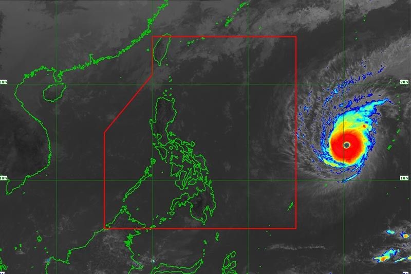
MANILA, Philippines — State weather bureau PAGASA said Typhoon Wutip might enter the Philippine area of responsibility on Thursday and would be given the name “Betty.”
In its advisory Monday morning, the state weather bureau said that the eye of “Wutip” is located at 1,740 km of east of southern Luzon as of 10 a.m.
The weather disturbance packs maximum sustained winds of 185 kph near its center and gustiness of up to 225 kph.
The typhoon is moving slowly heading northwest.
PAGASA said, however, that “Wutip” might downgrade into a tropical storm on Thursday when it is expected to enter the country's jurisdiction.
Forecast positions
- Tuesday morning: Outside PAR, 1,675 km east of southern Luzon (Virac, Catanduanes), typhoon
- Wednesday morning: Outside PAR, 1,570 km east of southern Luzon (Virac, Catanduanes), severe tropical storm
- Thursday morning: 1,440 km east of Baler, Aurora, tropical storm
— Kristine Joy Patag
Typhoon Wutip being monitored by PAGASA may enter the Philippine area of responsibility this Thursday, February 28, and it will be named "Betty."
As of 10 a.m., the eye of "Wutip" was located at 1,740 km east of southern Luzon outside PAR. It packs maximum sustained winds of 185 kph near the center and gustiness of up to 225 kph.
PAGASA says Tropical Storm Wutip is about to enter the Philippine area of responsibility and will be assigned the name "Betty."
The center of the tropical storm was estimated at 1,430 km east of Tuguegarao City, Cagayan outside PAR at 4 a.m. today.
It packs maximum sustained winds of up to 65 kph near the center and gustiness of up to 80 kph.
It is moving west-northwest at 25 kph.
The tropical storm poses no direct threat to any part of the country.
- Latest
- Trending


