LPA may enter PAR on Saturday as Tropical Depression Amang

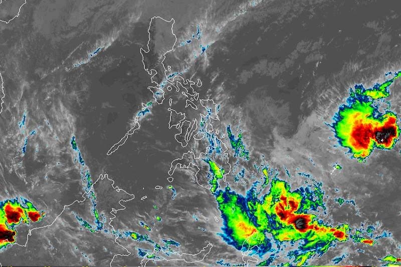
MANILA, Philippines — The low pressure area off Mindanao may develop into a tropical depression—the first to hit the country this year—within 24 hours, state weather bureau PAGASA said.
In a press briefing Friday, PAGASA also said the new weather disturbance may enter the Philippine area of responsibility on Saturday. Once it enters the country’s jurisdiction, the LPA will be named “Amang.”
The potential tropical depression is expected to make a landfall over CARAGA on Sunday. It may revert to LPA while crossing land like Tropical Depression Usman but PAGASA stressed that the downgrade does not imply that the weather will rapidly improve and the threat of flooding and landslides will be immediately reduced.
“Sana po ay hindi tayo magkumpiyansa dahil ang sinasabi low pressure area lang iyan. Hindi po puwedeng magkumpiyansa kasi pag low pressure area ay puwede po magbigay ng malalakas na ulan,” said PAGASA administrator Vicente Malano.
If the LPA intensifies into a tropical depression, signal number 1 may be hoisted over the provinces in the Samar-CARAGA area by Saturday, the weather agency said.
By Saturday evening, moderate (2.5 to 7.5 mm per hour) to heavy (7.5 to 15 mm per hour) rains are expected to be felt over eastern Visayas, CARAGA, Compostela Valley and Davao Oriental.
Residents of Bicol Region, eastern Visayas, CARAGA, central Visayas, Compostela Valley, Davao Oriental, southern Quezon, Mindoro provinces, Romblon and Marinduque may experience moderate to heavy rains by Sunday.
By Monday, moderate to heavy rains will prevail over Bicol Region, eastern Visayas, southern Quezon, Mindoro provinces, Romblon and Marinduque.
“Residents in these areas, especially those living in areas at high risk of flooding and landslides, are advised to take precautionary measures,” PAGASA said.
As of 8 a.m. Friday, the LPA was last seen 1,390 east of Hinatuan, Surigao del Sur. — Gaea Katreena Cabico
- Latest
- Trending


