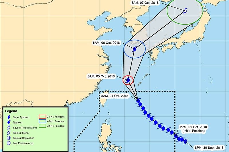
‘Queenie’ weakens anew as it heads to Japan

MANILA, Philippines — Typhoon Queenie (international name: Kong-rey) has weakened further as it continues to move away from the country’s jurisdiction, state weather bureau PAGASA said.
“Queenie” is expected to leave the Philippine area of responsibility between Thursday evening and Friday early morning.
As of 10 a.m., the eye of the typhoon was seen 665 kilometers east northeast of Basco, Batanes.
It now carries maximum sustained winds of 140 kilometers per hour near the center from the previous 160 kph and gusts of up to 170 kph from the previous 195 kph.
Moving north northwest at 15 kph, “Queenie” is heading toward southern Japan. It is also expected to barrel toward the East China Sea and Jeju Island in South Korea.
The trough or extension of “Queenie” will bring light to at times moderate rains over the eastern section of the country.
Heavy rain showers with lightning and strong winds are expected over Metro Manila, Bulacan, Rizal and Quezon.
PAGASA raised gale warning over the Ilocos region, Batanes, Babuyan Groups of Islands, Cagayan, Isabela, Aurora, Quezon province, Camarines provinces, Catanduanes and Sorsogon. Sea travels in these areas remain risky.
Forecast positions
- Friday morning: 840 km north northeast of Basco, Batanes (outside PAR)
- Saturday morning: 1,525 km north northeast of Basco, Batanes (outside PAR)
- Sunday morning: 2,695 km north northeast of Basco, Batanes (outside PAR)
— Gaea Katreena Cabico
- Latest
- Trending


