US forecast shows 'Ruby' to be near Metro Manila
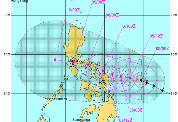
MANILA, Philippines - The state weather bureau warned on Friday that Typhoon "Ruby" may not spare Metro Manila while the forecast of the United States Joint Typhoon Warning Center (JTWC) even showed that the center of the howler may move near the nation's capital.
In a televised press briefing, PAGASA forecaster Chris Perez said Metro Manila may be covered by the outermost rainband of Ruby - which has a 700-kilometer diameter - if the typhoon maintains its west northwest track toward the northern part of the Mindoro provinces.
Perez said Ruby will affect Metro Manila, which may experience light to moderate rains or moderate to heavy rains starting Sunday morning
He also advised provinces near Metro Manila to be on alert for Ruby's movement and possible effects.
"[Just] because the eye of Typhoon Ruby is expected to cross the central part of Visayas or southern part of Luzon, it doesn't necessarily mean that it will not affect Metro Manila," Perez said in a mix of English and Filipino.
Perez, however, is also not ruling out the possibility of Ruby deviating from the track projected by PAGASA.
He said if Ruby shifts into a more northward track, then Metro Manila should expect more rains.
Varying forecast tracks
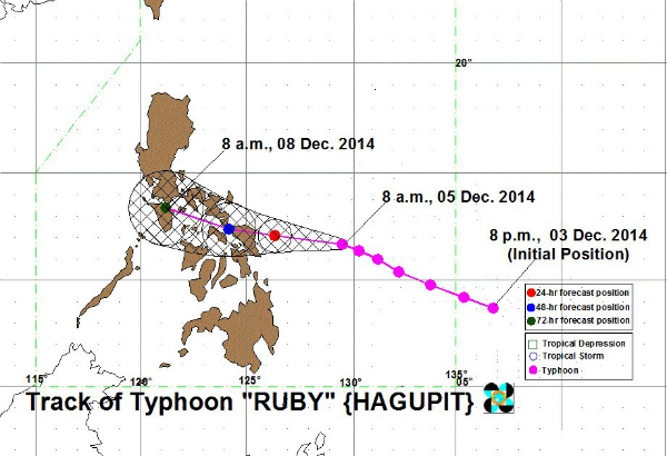
PAGASA located the eye of Typhoon Ruby at 435 kilometers east of Borongan, Eastern Samar at 10 a.m. today. The agency expects it to be at 60 kilometers east of Masbate City by Sunday morning and within the vicinity of Calapan City, Oriental Mindoro by Monday morning.
Meanwhile, the latest forecast track from the JTWC showed that the typhoon's center will instead traverse the Bicol region and then head for Calabarzon. By Tuesday, the typhoon's center is projected to be just 64 kilometers away from Manila. The Hawaii-based agency previously predicted that Ruby will cross the nation's capital.


In a press briefing earlier this morning, PAGASA presented the forecast tracks made by various international weather agencies. Except for the JTWC projection, all of the tracks showed that Ruby will cross Visayas and not Luzon.
Science and Technology Secretary Mario Montejo admitted that projecting Ruby's track is "very complex."
"Sometimes, 'yung ibang agencies, their models would show the similar tracks kamukha nung kay Yolanda. Pero ito (Ruby), medyo trickier," he said in a televised press briefing this morning.
But Montejo believes that so far, PAGASA's forecast is correct and that most of the projections made by international weather agencies are starting to agree on the same track.
"Ang actual na daan ng bagyo ay malapit na malapit sa PAGASA track. At the same time, ngayon, almost all international models ay very similar na ngayon sa PAGASA track," Montejo said.
But whether or not it will traverse and directly hit the National Capital Region (NCR), residents in the metro should still prepare for the approaching typhoon, Interior and Local Government Secretary Manuel Roxas II said.
"Dapat maghanda rin ang NCR, yun ang atas ng Pangulo," he said in the televised press briefing.
Landfall, Storm signals
In its latest weather bulletin, PAGASA said Ruby is expected to make landfall by Saturday evening over the Eastern Samar-Northern Samar area and it will be associated with strong winds, 4-5 meter storm surges and heavy to intense rainfall.
Ruby is expected to exit the Philippine Area of Responsibility by Wednesday.
Public storm warning signals have been raised over the following areas:
Signal no. 2:
Sorsogon
Ticao Island
Masbate
Northern Samar
Eastern Samar
Samar
Biliran
Leyte
Southern Leyte
Northern Cebu including Cebu City
Bantayan Island and Camotes Island
Signal no. 1:
Catanduanes
Albay
Camarines Norte
Camarines Sur
Burias Island
Romblon
Capiz
Iloilo
Antique
Aklan
Negros Oriental
Negros Occidental
Rest of Cebu
Siquijor
Bohol
Surigao del Sur
Agusan del Norte
Surigao del Norte
Dinagat Island
Siargao Island
Misamis Oriental
Agusan del Sur
Camiguin Island
- Latest
- Trending


