'Luis' approaches land, may become a storm
MANILA, Philippines — Tropical depression "Luis" entered the Philippine Area of Responsibility and moved closer to Luzon, while slightly intensifying over the Philippine Sea, the state weather bureau said.
In its 11 a.m. advisory on Friday, the Philippine Atmospheric, Geophysical and Astronomical Services Administration (PAGASA) said the 12th cyclone of the year to enter the country is moving west-northwestward at 26 kilometers per hour, packing maximum sustained winds of 55 kph near the center.
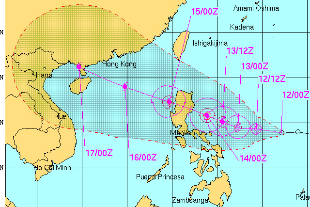
Luis' center was spotted 780 km east of Virac, Catanduanes as of 10 a.m. on Friday.
Weather forecaster Meno Mendoza said in a state report that Luis is expected to take three days to make a landfall wihle cutting across northern Luzon before it exits the country's geographical region.
He said Luis is also likely to further intensify into a tropical storm.
LUIS: All the weather updates you need in one page

Tropical depression Luis' track as of Friday, September 12. Google Earth/NOAA/JTWC
"Luis is expected to be at 480 km east of Casiguran, Aurora by tomorrow morning (Saturday) and at 180 km northeast of Casiguran, Aurora by Sunday morning," PAGASA noted in the advisory.
"By Monday morning, it is expected to be 70 km west northwest of Laoag City," it added.
Mendoza said Luis will cause cloudy skies with light to moderate rainshowers and thunderstorms over Visayas, Mindanao and Bicol region.
The rest of the country, meanwhile, will continue to have partly cloudy to mostly cloudy skies with possible rainshowers mostly in the afternoon or evening due to localized sandstorms.
Moderate to occasionally strong winds blowing from the southwest to west will prevail over Southern Luzon, Visayas and Mindanao and the coastal waters along these areas will be moderate to occasionally rough.
- Latest
- Trending


