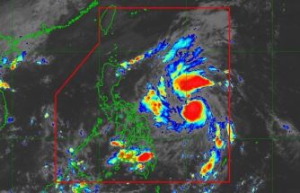
Zoraida to bring heavy rains over Mindanao
MANILA, Philippines - A tropical depression yesterday entered the Philippine area of responsibility near Mindanao as the country is still reeling from Super Typhoon Yolanda.
The state weather bureau advised residents of Mindanao and the southern part of central Visayas to brace for heavy rains today due to Tropical Depression Zoraida.
Zoraida was forecast to make landfall over Surigao del Sur or Davao Oriental this afternoon, said Rene Paciente, weather forecasting section chief of the Philippine Atmospheric, Geophysical and Astronomical Services Administration (PAGASA).
According to Weather Philippines, Zoraida is expected to accelerate northwestward in the next 24 hours, turning west-northwestward in 48 hours.
“On the forecast track, the core of Zoraida will make landfall along the border of Surigao del Sur and Davao Oriental, passing across Agusan del Sur, Bukidnon and Misamis Oriental on Tuesday afternoon through evening and will traverse the Mindanao Sea early Wednesday morning on its way to the Sulu Sea,†it said.
As of 11 a.m. yesterday, storm warning Signal No. 1 was hoisted over Siquijor, southern Cebu, Bohol, Negros Oriental, Negros Occidental, southern Antique, Iloilo, Guimaras, Dinagat Island, Siargao Island, Agusan del Norte, Agusan del Sur, Surigao del Norte, Surigao del Sur, Davao Oriental, Compostela Valley, Davao del Norte, Samal Island, Bukidnon, Misamis Oriental and Camiguin Island.
Classes were suspended in at least seven areas in Mindanao.
Zoraida is the 25th tropical cyclone to enter the country this year and the second weather disturbance this month.
As of 4 p.m., it was spotted at 634 kilometers southeast of Hinatuan, Surigao del Sur with maximum sustained winds of 55 kilometers per hour near the center.
It was projected to move west northwest at 30 kph.
Paciente said moderate to heavy rains could affect the areas under storm warning signal beginning today.
Zoraida is predicted to be in the vicinity of Agusan del Sur this afternoon, and 100 kms southwest of Coron, Palawan tomorrow afternoon.
By Thursday afternoon, it would be at 810 kms west of Ambulong, Batangas.
The new disturbance, however, was not expected to be as powerful as Yolanda, Paciente said.
“It is expected to make landfall as a tropical depression,†he said.
But he added that a tropical depression is harder to track than a typhoon.
“Zoraida is not a behaved storm and has erratic movement,†he said.
Paciente said the highest storm signal that could be raised in areas along the path of Zoraida is Signal No. 2.
He said the possibility of it reaching a storm category (65 kph) remains as it is still over the sea.
Paciente, meanwhile, said good weather would prevail over the rest of the country, including Metro Manila, this week.
He said the intertropical convergence zone dumped light to moderate rains over Mindanao yesterday.
PAGASA warned against sea travel in the northern seaboard of northern Luzon and the eastern seaboards of northern and central Luzon due to the surge of the northeast monsoon.
– With Edith Regalado
- Latest
- Trending


