'Domeng' updates

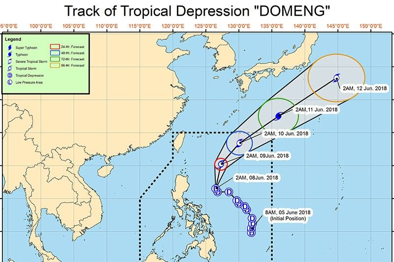
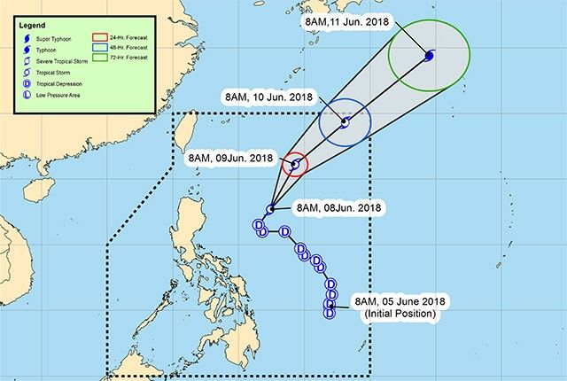
PAGASA says Tropical Storm Domeng accelerates north northwestward and is now outside the Philippine Area of Responsibility.
The eye was spotted 990 kilometers east northeast of extreme northern Luzon.
Monsoon rains enhanced by Typhoon Domeng (international name: Maliksi), which left the Philippine area of responsibility yesterday, are expected over Bicol, Oriental Mindoro, Marinduque and Romblon.
PAGASA warns against possible flooding or landslides in the said areas.
Meanwhile, the state weather bureau says partly cloudy to cloudy skies with isolated rain showers or thunderstorms will prevail over Northern Samar.
Moderate to strong winds blowing from the southwest will be experienced with moderate to rough seas over Bicol and Northern Samar. Strong to gale winds blowing from the southwest will prevail with rough to very rough seas over Oriental Mindoro, Marinduque and Romblon.
Metro Manila may experience rains until Thursday, PAGASA's three-day forecast shows.
The state weather bureau says Domeng has intensified into a typhoon as it departed the Philippine Area of Responsibility.
The typhoon's center was located at at 1,045 kilometers East Northeast of Basco, Batanes (outside PAR) (25.1°N, 130.8°E).
Domeng is forecasted to move northeast at 37 kilometer per hour.
As of 5 p.m., “Domeng” has intensified into a severe tropical storm with maximum winds of 90 km/h and gustiness of up to 115 km/h.
Flooding in the province of Cavite is “threatening,” the state weather bureau says.
Domeng is expected to leave the Philippine Area of Responsibility on Sunday morning.
PAGASA says Tropical Storm Domeng continues to enhance the southwest monsoon, bringing rains that may also trigger flashfloods and landslides over Luzon and Western Visayas for the next two days.
The Manila International Airport Authority has announced the cancellation of several domestic flights due to Tropical Storm "Domeng."
Cebu Pacific 513/514 Manila-San Jose-Manila
CebGo 6073/6074 Manila-Tablas-Manila
Skyjet 713/714 Manila-Busuanga-Manila
Tropical Storm Domeng is expected to bring floods or landslides due to moderate to occasional heavy rains over Metro Manila, Ilocos Region, Calabarzon, Mimaropa, Bicol Region, Western Visayas and the provinces of Bataan and Zambales.
"Domeng" was last seen at 505 kilometers east of Basco, Batanes with maximum sustained winds of 80 kilometers per hour near the center and gustiness of up to 95 kph.
It is forecast to move north northeast at 17 kph.
Tropical Storm Domeng maintains its strength Friday afternoon as it continues to exit the country in a northeastern direction.
In its 5 p.m. bulletin, state weather bureau PAGASA says “Domeng” was last seen 560 kilometers east of Aparri, Cagayan.
It packs maximum sustained winds of 65 kilometers near the center and gustiness of up to 80 kilometers per hour.
While no tropical cyclone warning signal has been raised in any area of the country, “Domeng” is enhancing the southwest monsoon or “habagat.”
Cyclone "Domeng" is now a tropical storm, intensifying as it moves away from the country. PAGASA's advisory says it was spotted 655 kilometers east of Tuguegarao City, Cagayan at 10 a.m. today.
Domeng is seen to enhance the southwest monsoon or "habagat" to cause rains over Metro Manila and the rest of the western sections of Luzon and Visayas this weekend.

Gear up for a rainy weekend.
PAGASA says Tropical Depression Domeng is expected to bring moderate to occasionally heavy rains over Southern Luzon and Western Visayas and scattered rain showers over the rest of Luzon and of Visayas in the next 24 hours.
The tropical depression's eye was last spotted at 470 km east of Casiguran, Aurora. It continues to barrel north at 15 kph.
It packs maximum sustained winds of 60 kph and gustiness of 75 kph.
- Latest
- Trending


