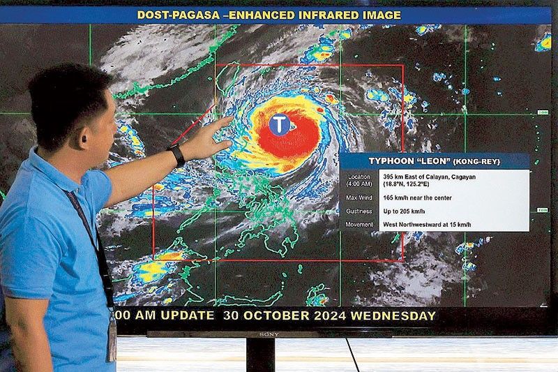
Leon becomes Super Typhoon

MANILA, Philippines — The Philippine Atmospheric, Geophysical and Astronomical Services Administration (PAGASA) warned of a high risk of storm surge in Northern Luzon as Super Typhoon Leon passes over the Philippine Sea.
Tropical cyclone wind signal No. 4 has been raised over Batanes, with winds greater than 118 to 184 kilometers per hour expected.
PAGASA said the storm surge could be more than three meters high in the provinces of Batanes and Cagayan.
“There is a possibility of life-threatening inundation from rising sea water along with high waves in the low-lying coastal communities,” PAGASA said.
It warned of significant damage to communities in low-lying coastal areas in Basco, Itbayat, Ivana, Mahatao, Sabtang, Uyugan in Batanes, as well as in Calayan in Cagayan.
PAGASA said the hoisting of wind signal No. 5 has not been ruled out. Leon (Kong-Rey) was forecast to make close approach or make landfall in Batanes last night or this morning and will be near or at peak intensity during its closest approach.
Signal No. 3 was hoisted over the eastern portion of Babuyan Islands and the northeastern portion of mainland Cagayan.
Meanwhile, signal No.2 was raised over the rest of Babuyan Islands, the rest of mainland Cagayan, northern portion of Isabela, Apayao, Kalinga, northern and eastern portions of Abra and the eastern portion of Mountain Province (Paracelis) and Ilocos Norte.
TCWS No. 1 was raised over the rest of Isabela, Quirino, Nueva Vizcaya, the rest of Mountain Province, Ifugao, Benguet, the rest of Abra, Ilocos Sur, La Union, Pangasinan, Nueva Ecija, Aurora and northeastern Tarlac.
Leon was monitored 215 km east southeast of Basco, Batanes as of 4 p.m. and was moving northwestward at 20 kph, carrying maximum sustained winds of 185 kph near the center and gustiness of up to 230 kph.
Leon is forecast to make landfall in Taiwan this afternoon and may exit the Philippine area of responsibility by tonight or early Friday morning. The trough of Leon may bring scattered rains over Metro Manila, the Visayas and the rest of Luzon.
Mindanao may see isolated rains due to localized thunderstorms.
‘Prepare for Leon’
President Marcos yesterday called on local governments to prepare for the impact of Leon, which has developed into a Super Typhoon and is posing a threat to northern Luzon.
“Unfortunately, it seems that another one is coming so we have to prepare for it thoroughly,” the President said during the opening of the Maersk Optimus Distribution Center in Calamba, Laguna.
Office of Civil Defense administrator Ariel Nepomuceno said the government is always assuming the worst-case scenario in its preparations. Agencies are replenishing food and non-food items and are making sure that water is available and rescue teams are ready, he added. ?The OCD also urged yesterday residents and local government units in Central Luzon, Calabarzon and Bicol to prepare for the arrival of Leon.
The National Disaster Risk Reduction and Management Council yesterday said 2,951 families from Regions 1, 2 and 3 were evacuated. In Region 5, at least 40,249 families or 161,768 individuals remain in evacuation centers.
Dams release water
As of 8 a.m. on Wednesday, dam officials resumed the release of water from Ambuklao Dam and Binga Dam, both in Benguet, while Magat Dam in Isabela continues to release water.
One gate of Ambuklao Dam was opened at 0.5 meter and began releasing water at 91.19 cubic meter per second (cms) while one gate of Binga Dam was opened at 0.5 meter and started releasing water at 78.28 cms. One gate of Magat Dam remained open at two meters since last week, releasing water at 355 cms.
The water level of Angat Dam has reached 202.53 meters while Ipo Dam in Bulacan dropped by 0.30 meters and reached 100.24 meters.
Cancelled flights
Flag carrier Philippine Airlines cancelled yesterday six domestic flights while Cebu Pacific cancelled four domestic flights due to bad weather.
PAL and CEB said affected passengers can convert their tickets to non-expiring travel credits equivalent to the unused segment of the ticket, excluding ticketing service charge.
Meanwhile, 134 people were stranded in ports across Southern Tagalog and Bicol due to strong winds and rough seas triggered by Leon as of noon of Oct. 30, the Philippine Coast Guard reported.
Also stranded were 19 rolling cargoes, five ships and 11 motorized boats in four Coast Guard districts in Southern Tagalog, Bicol, Northwestern Luzon and in Northeastern Luzon. Thirty-eight vessels and 13 motorized boats have taken shelter due to bad weather.
The Philippine Ports Authority reported cancellation of trips in three of their Port Management Offices. At noon yesterday, their PMO in Mindoro said trips of all fastcraft going to Batangas have been cancelled. – Alexis Romero, Pia Lee-Brago, Bella Cariaso, Rudy Santos, Evelyn Macairan
- Latest
- Trending


