Signal No. 1 up in 4 areas as 'Nina' maintains strength
December 23, 2016 | 6:45pm

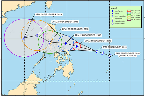
Track of Severe Tropical Storm Nina as of 5 p.m. Friday, Dec. 23, 2016. PAGASA/Released
MANILA, Philippines — Signal No. 1 is raised over four areas as Severe Tropical Storm Nina (international name: Nock-ten) maintained strength, the Philippine Atmospheric, Geophysical and Astronomical Services Administration (PAGASA) said Friday.
The state weather bureau raised Tropical Cyclone Warning Signal (TCWS) No. 1 over Catanduanes, Sorsogon, Northern Samar and Eastern Samar.
In its 5 p.m. severe weather bulletin on Friday, PAGASA said "Nina" has maintained its strength and continues to move in a west-northwest direction at 20 kph.
"Nina" brings an estimated moderate to heavy rainfall amount within its 400 km diameter.
It packs maximum sustained winds of up to 105 kph near the center and gustiness of up to 130 kph.
The eye of "Nina" was estimated at 700 km east of Borongan City, Eastern Samar at 4 p.m. Friday.
The severe tropical storm is expected to intensify into a typhoon within 24 hours before making landfall over Catanduanes by Sunday (December 25) afternoon or evening. But it may weaken by Monday once it has passed over the land mass area.
PAGASA warned that sea travel is risky over the seaboards of northern Luzon.
Metro Manila may expect Signal No. 2
PAGASA said Metro Manila may experience Signal No. 2 by Monday (December 26). Meanwhile, the state weather bureau said it may issue a TCWS over Bicol 11 p.m. Friday.
Nina is expected to exit the Philippine area of responsibility (PAR) on Wednesday (December 28).
Forecast positions
- 24 hours (Saturday afternoon): 270 km northeast of Borongan City, Eastern Samar
- 48 hours (Sunday afternoon): 65 km northeast of Virac, Catanduanes
- 72 hours (Monday afternoon): In the vicinity of Silang, Cavite
- 96 hours (Tuesday afternoon): 220 km west-northwest of Iba, Zambales
- 120 hours (Wednesday afternoon): 480 km north of Pagasa Island, Palawan (outside PAR)
— Kristian Javier
BrandSpace Articles
<
>
Philstar
x
- Latest
- Trending
Trending
Latest
Trending
Latest
Recommended


